Often the most difficult aspect of committing to a big endeavor, such as climbing a 14,000-foot mountain in winter, is knowing where to start. It’s a common misconception for summer hikers that winter is off limits, a no-man’s-land of arctic temperatures, sheer ice faces and hourly avalanches. That’s simply not true. I previously wrote a basic overview for exploring the alpine in the so-called offseason, and now I’ll attempt to answer another oft-repeated question: Which peak(s) to try first?
As a disclaimer, none of these routes offer guaranteed safety. It’s imperative for anyone venturing into the winter backcountry to have at least a basic understanding and awareness of avalanche terrain. The stakes are also exponentially higher. More care needs to be given to gear selection, route knowledge, emergency preparedness and other safety precautions. A forced night out in the summer could be uncomfortable. A forced night out in the winter could be fatal.
I chose the following five mountains based on access, minimal avalanche danger, ease of routefinding and general popularity. Many others are doable as relatively safe winter daytrips. These are simply the lowest-hanging fruit.
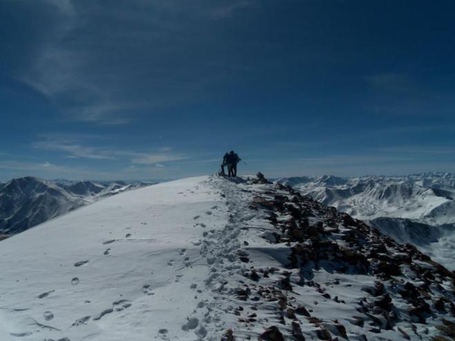
1. Quandary Peak
Winter Trailhead: Quandary (same as summer)
Winter Route: East Ridge (same as summer)
Winter Mileage: 7 miles
Winter Elevation Gain: 3,500’
When asked what’s the easiest 14er to attempt in the summer, an argument could be made for several different mountains. When the same question is asked for the winter months, there really is only one best answer. It’s Quandary Peak.
Quandary’s standard trailhead is right off Highway 9, which is consistently plowed. No extra effort is needed to reach the summer starting point. It’s also the most popular winter 14er, meaning there likely will be an established snow trench unless you’re climbing immediately after a major storm. Snowshoes are still recommended, but the need to break your own trail is rare. Staying on the ridge nearly negates avalanche danger except in extreme conditions, though venturing out onto the East Face can put you in harm’s way.
In short, if you hug the ridgeline, carry a bit of extra gear, have a good forecast, enjoy minor suffering and go in moderate or better avalanche conditions, Quandary isn’t much more challenging in winter than summer.
2. Mt. Bierstadt
Winter Trailhead: Roughly 1.75 miles below Guanella Pass at the Guanella Pass Campground (Georgetown side)
Winter Route: West Slopes (same as summer)
Winter Mileage: 10.5 miles
Winter Elevation Gain: 3,800’
The only thing more difficult about Mt. Bierstadt in the winter is about three miles of road walking. The west-facing slopes harboring the summer route are often blown clear by intense winter winds, with lengthy segments of the trail exposed above treeline. Some avalanche danger is possible during part of the approach up the road, as well as while gaining the upper shoulder at around 12,000 feet. In most conditions, a safe line is apparent.
Many people try to save themselves a couple hundred feet of elevation gain by leaving the road early and making a beeline for Bierstadt without visiting the summit of Guanella Pass. I generally advise against this, as it takes you through a soul-sucking patch of willows. In my experience, it’s easier to stick to the road and suck up the minimal extra gain.
3. Mt. Elbert
Winter Trailhead: South Mt. Elbert
Winter Route: East Ridge
Winter Mileage: 12.5 miles
Winter Elevation Gain: 4,900’
See the other side of famous Mt. Elbert. The hardest route statistically on this list also comes with perhaps the lowest avalanche danger. Mt. Elbert’s broad and gentle East Ridge seldom gets steep enough to allow a slide. Like many winter routes, it starts with a two-mile stroll along a closed 4WD road before joining the South Mount Elbert Trail. In some seasons, especially early on, all or part of this road can be driven.
Prepare your mind for the upper portions of this hike. It includes several heartbreaking false summits. Combined with the incessant wind that almost always berates Colorado’s highest peak in the winter, this is as much an exercise in mental fortitude as it is physical endurance.
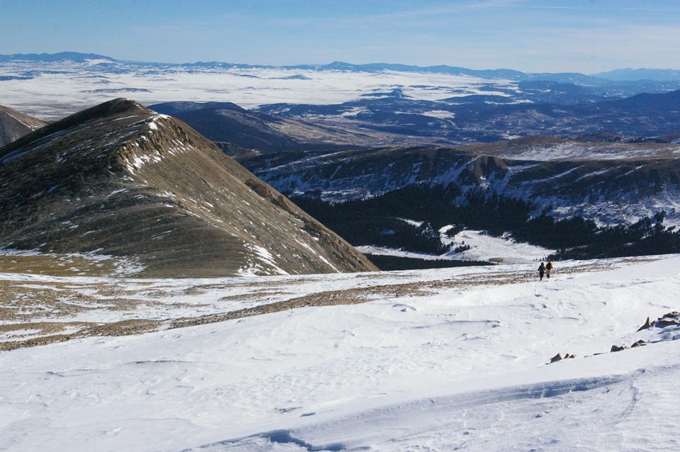
4. Mt. Sherman
Winter Trailhead: About 2.5 miles short of the standard summer 4WD gate
Winter Route: South Slopes
Winter Mileage: 8.5 miles
Winter Elevation Gain: 3,100’ to 3,500′, depending on parking area
Be careful on this popular winter peak. Avalanche-safe lines abound, but the danger is insidious. Venturing even a hundred feet in the wrong direction could put you in a slide area. Along with Quandary and Bierstadt, this is probably the most attempted winter route, due to its short length. I personally know at least three parties that have gotten caught in slides on this mountain. Avalanche terrain awareness and careful decision making are essential.
The starting point for this hike varies considerably. I’ve logged four attempts in winter and began from a different staging area each time. In general, plan to start about a mile below the Leavick site. Anything closer is a bonus. Walk the road to just before the summer 4WD gate, then veer right. The terrain here can be confusing and deceptive. Select a cautious line and make your way toward the obvious shallow gully to the right of the Mt. Sherman summit, targeting the broad plateau between Sherman and White Ridge.
It’s important to take this alternate route and not attempt to stay on the standard trail. Gaining the Sheridan-Sherman saddle on the summer path comes with considerable avalanche risk, including a large and reliable cornice.
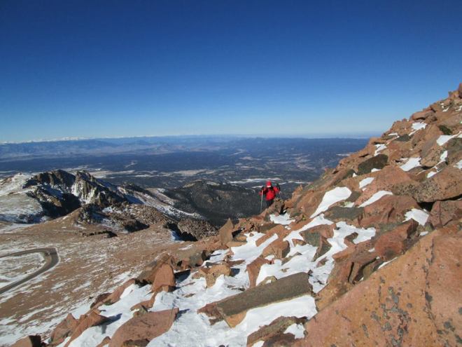
5. Pikes Peak
Winter Trailhead: Crags Campground
Standard Winter Route: Northwest Slopes
Winter Mileage: 14 miles
Winter Elevation Gain: 4,300’
It would be hard for 14 miles to feel much shorter. This gentle route maintains an easy grade most of the way, with only a few steep sections. The popularity of the Crags area as a dayhike also means that a trench is a nearly permanent fixture. The upper portion of the hike, above Devil’s Playground, parallels the summit road. Because Pikes stands largely alone, it’s often subjected to blasting winds. Large sections of the wide, obvious trail above treeline were visible every time I’ve done this peak with snow.
In contrast with Mt. Evans, the road up Pikes Peak remains open year-round, weather permitting. It’s hard to express the sheer joy that’s felt while eating a donut and drinking hot chocolate in the confines of a brick shelter after seven miles hiking uphill in a subzero wind chill. It’s also hard to express the willpower that’s necessary to leave that shelter for the seven-mile hike down.

bought time buddy! Is Sherman Class 5? Do I need my snowshoes? If my hands get cold can I stop at the saddle? nice little write up Jeffro!
LikeLike
Reblogged this on she dreams awake… and commented:
This is awesome advise; had to share!
LikeLike
cool article, the pikes peak hyperlink takes you to the mt sherman route though.
LikeLike
I have noticed that your website needs some fresh articles.
Writing manually takes a lot of time, but there is tool for this time consuming task, search for: Wrastain’s
tools for content
LikeLike
Very nice website!
LikeLike